Wildland Fires and Smoke

BACKGROUND
Wildfires generate air pollution known as particulate matter. Particulate matter includes tiny solid or liquid particles. Fine particulate matter is also known as soot. Particulate matter can cause health problems when inhaled. The severity of health issues depends on weather conditions and smoke density.
Colorado saw two of the largest wildfire seasons on record in 2018 and 2020. These fires burned more than 100,000 acres, including sections of Rocky Mountain National Park. The Clean Air Status and Trends Network (CASTNET) operates a monitoring site (ROM406) in Rocky Mountain National Park. This site measures ozone and weather. Wildfire smoke data from the National Oceanic and Atmospheric Administration’s (NOAA) Hazard Mapping System (HMS) were used to characterize the impact of smoke on air quality at ROM406 during 2018 and 2020. The smoke density was classified using three levels: light, medium and heavy. Comparing HMS data with data from CASTNET measurements provided insight on smoke densities and the amount of particulate matter present. Wildfire smoke impacts the ROM406 site, influencing visibility, particulate matter, and ozone measurements at Rocky Mountain National Park. Additional work is necessary to understand the effects of wildfire size, distance, and duration to find the impact of smoke on ozone.
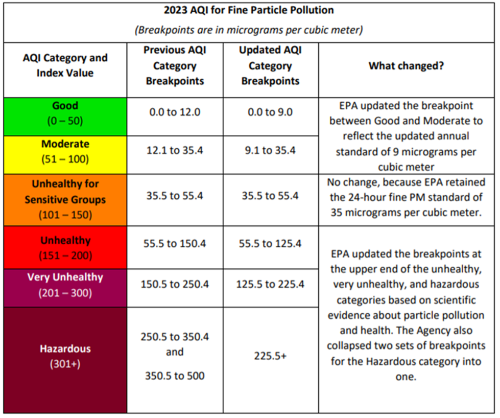
Many people use EPA’s Air Quality Index (AQI) to predict how air quality might affect their health on a day-to-day basis. The EPA is lowering the level of the particulate matter standard from its previous value of 12 micrograms per cubic meter (ug/m3) to 9 ug/m3. The effective date for the new standard is today–May 6, 2024. The AQI breakpoints–the PM levels that define a moderate rather than a good day, for example–are also changing. See the chart below for changes to the AQI:
RESOURCES
What is the smoke over the United States right now? National Oceanic and Atmospheric Administration (NOAA) uses satellites to map locations of fire and smoke plumes and publishes a daily map: https://www.ospo.noaa.gov/Products/land/hms.html#maps
SAMPLE SOCIAL MEDIA POSTS
What is in the air right now? Check out the AQI to learn about how wildfire smoke affects the air you breathe. https://www.airnow.gov/wildfires/